Other name:The City of Coffee
Climatic conditions:Tropical highland climate
Language: Portuguese
Dialing code: 55 (country code) 11 (city code) |
|
Location: It is located to the east of the Chris Lino Plateau, 60 kilometers from the Atlantic coast, in the southeastern part of the State of Sao Paulo
Emergency call: Emergency call 190; Fire 193; Police 190; First aid 192
Currency:Brazilian Real (BRL)
Exchange rate: 1 U.S. Dollar =1.8325 Real; 1 Euro =2.4576 Real(for reference only) |
1. Airport Name:Sao Paulo Guarulhos International Airport
2. Basic InformationThe Sao Paulo Guarulhos International Airport of Brazil (airport code GRU) is also known as the "Congonhas International Airport". It ranks the first in terms of transported passengers among the busiest airports in the country and in all of South America. It is located northeast of Sao Paulo, linked to the city by the Ayrton Senna and Presidente Dutra highways.
3. Terminal InformationThe Sao Paulo Guarulhos International Airport currently has two terminals, T1 and T2. Air China operates in T2.
4. Location of Check-In CountersAir China’s check-in counters are located at counters No. 5-14,Wing C,Terminal 2.
5. Airport DirectionsN/A
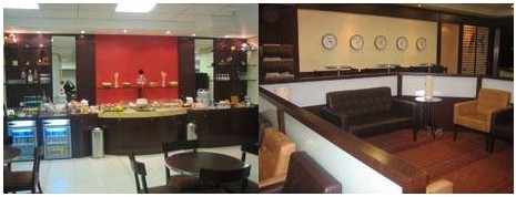
6. VIP LoungeAir China’s VIP lounge is located in Area A,T1.
Operating hours:
International First Class & Business Class: 06:00 - 24:00.
 7. Airport Transportation
The airport is located approximately 25 kilometers / 18 miles from the city center.)
Airport shuttle Bus:The airport bus departs for the city center and the Congonhas domestic airport, at 30-minute intervals. In addition, there are minibuses available for trips to the city center. It takes about 40 minutes for both the airport bus and the minibus to reach destinations in the city.
Taxi:It takes about 20 to 40 minutes and costs about 70-80 Brazilian Real to reach the city.
Car Rental Service:Car rental companies include: Avis, Budget, Hertz, Localiza Rent a Car, Interlocadora and Unidas. Passengers are advised to contact the various car rental companies for more details.
8. Linkhttp://www.infraero.gov.br/
1. Subway
The Metropolitano de Sao Paulo currently has five color-coded subway lines: Blue Line 1, Green Line 2, Red Line 3, Yellow Line 4 and Lilac Line 5. Another company, Companhia Paulista de Trens Metropolitanos (CPTM), is operating the same lines as those of the Metropolitano de Sao Paulo, and railway lines which have been changed into light rails. There are six such lines in total, namely Lines 7, 8, 9, 10, 11 and 12. The Subway and CPTM are linked together at several stations.
2. Bus
Public transport in Sao Paulo is very convenient; operating hours usually are from 05:00 to 00:00.
3. Taxi
Metered taxis are one of the main means of transport in Sao Paulo, with tip percentages expected to be 5 to 10% of the fare and fractions are rounded to the nearest whole Real. A 25% surcharge applies to fares for taxi service on Sundays and at night.
Sao Paulo, located near the Tropic of Capricorn and affected by its high plateau location near the Atlantic Ocean, it has a tropical highland climate, which is mild and humid.
The annual average temperature here is 18 degrees Celsius, with warm temperatures in the winter and cool temperatures in the summer. The average temperature during the coldest month (July) is 14 degrees Celsius, and the average temperature during the hottest month (February) is 21 degrees Celsius. Annual average precipitation is about 1.4 meters. Sao Paulo has a very pleasant climate and any time of the year is suitable for a visit.

 |
|
 Add a Favorite
